 Catalogue PIGMA
/Human Activities/Marine Structures/Ports
Type of resources
Available actions
Topics
Keywords
Contact for the resource
Provided by
Years
Representation types
Scale
-
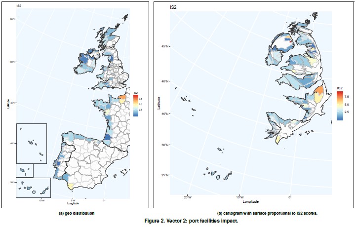
It contemplates the assessment of vulnerability due to passengers and goods transportation and cov- ers indicators related to sustainability awareness (energy efficiency, land use, etc.). Shipping has an environmental impact both in ports, as well as in the immediate vicinity of the ports. This vector tries to capture the impact of the port activity on vulnerability. Vector 2 indicators have been obtained from Eurostat and EcoPorts, a environmental initiative of the European port sector fully integrated into the European Sea Ports Organisation (ESPO) since 2011.
-
World list of seaports. In its 2021 version, the repository includes 13709 ports for 187 countries. The list of seaports has been drawn up on the basis of the information available in the European reference system of places used in the framework of the Common Fisheries Policy and, more particularly, by the Electronic Recording and Reporting System (ERS), the list of ports identified by the UNECE (2021-1). An assessment of the infrastructures present along the coastline made it possible to identify other ports that were not listed. Each geographical position has been verified with Google Earth in WGS84. Each port is associated with information relating to the country (ISO 3 coding), the UNECE or ERS 5-character coding, the name, the geographical position in WGS84 (latitude and longitude), the status of the port indicating whether it is referenced by Unece (UNECE), by the EU/ERS (ERS) or by both (UNECE/ERS) In case the port is not referenced by UNECE or ERS, the status is N/A. For French ports, the reference system integrates the ports of the French overseas departments and territories with the national codification. Inland ports have also been integrated in 2021.